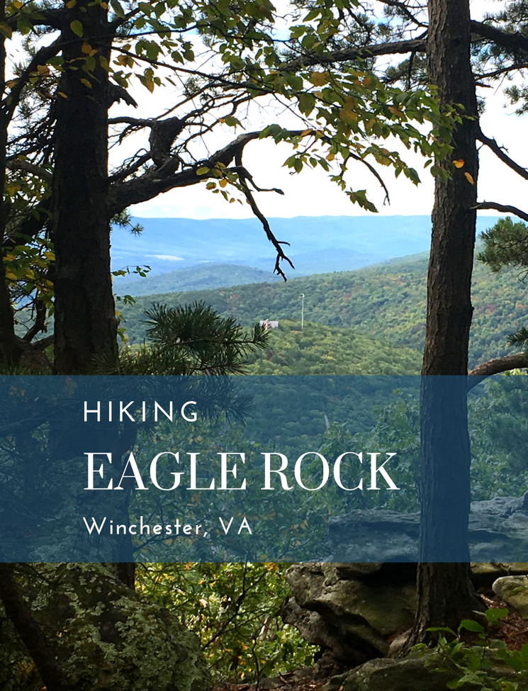
Hiking the Tuscarora Trail to Eagle Rock Overlook
This post may contain affiliate links. Click here to see what that means.
In Western Virginia, a short drive from Winchester or Woodstock, the Tuscarora Trail offers a number of hiking trails for the avid adventurer or casual day hiker. The trail includes the Eagle Rock overlook which provides some of the best views of the Great North Mountain Range.
The longer hike is a 7.2 out and back from US 48/55. The shorter, Eagle Rock Trail, begins at Dry Gap, VA609. The short hike is fairly easy, with just one “steep” climb. I made it without walking stick, so the hike is certainly family friendly.
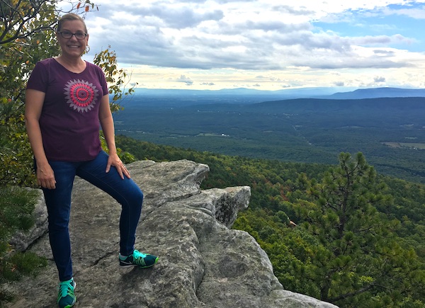
At the Eagle Rock overlook, a stone bench provides a great spot to picnic and enjoy the magnificent views. There are no fences here, so common sense dictates that hikers stay away from the edge of the rock overhang.
The Eagle Rock Trail passes through Capon Springs Hunt Club, which is private property, so stay on the trail and please, leave no trace. Bears also inhabit the area, so be aware. Our crew was pretty loud, so I think the bears decided to go another direction!
If you’re new to hiking, Winchester is a great place to start. The staff at Mountain Trails, an Outdoor Equipment Store and Education Center, will help you with supplies and offer advice for your hike.
The Tuscarora Trail
When I hike, I usually go to state parks with large parking lots, extensive signage and clear trail heads. The Tuscarora Trail is a bit more rustic — but a treasure well worth hunting for. Use this guide to find the trail head.
Landmarks along the way are included (though the light blue blazes are easy to find and follow.)

The Tuscarora Trailhead
Mile 0.0 is at the parking area along Route 48/55. Cross the road (carefully as the vehicles travel at high speeds) and follow the blue blazed Tuscarora Trail to the right. The trail runs along the border of Virginia and West Virginia.
Mile 0.25 provides a ridge view of Maddy Mountain and Little Sluice Mountain. The ridge trail is narrow along this section, so tread carefully.
Mile 0.77 passes to the right of a communications relay tower. Stay to the right to remain on the Tuscarora Trail.
Mile 1.40 passes a larger communications tower on the left. The blue blazed trail will descend to a saddle on the ridge.
Mile 1.79 intersects with the orange blazed connector trail which leads to the Hawk Recreation Area. At this point, the blue blazed trail Tuscarora Trail continues straight. The privately owned Capon Springs Hunt Club borders the trail on the right. The trail continues to the parking area at Dry Gap and VA/690/Capon Springs Grade Road.
Eagle Rock Trail (start here for the shorter, 2.1 mile trail)

I climbed this section of the trail. The first half involves a wide, gradual incline that’s easy to maneuver. Views to the left look down through woodlands — beautiful as fall leaves turn gold and red.
Mile 2.58 is the parking area for the Eagle Rock Trail along VA690/Capon Springs Grade Road. Cross the road and follow the blue blaze marks as the trail climbs north to the saddle between Great Northern Mountain and Spring Mountain.
Mile 3.08 is where the trail splits. Stay to the right to follow the blue blazed trail. The incline gets significantly steeper here, though for less than half a mile. We made the hike in jeans and tennis shoes, not traditional hiking gear, and while it was tiring, I did not struggle. (I hike regularly, though. This might be tough for those who are generally inactive. Pace yourself — the view is worth the effort.)
Mile 3.55 marks the ridge where the trail turns to the left. The trail is a little more narrow here and offers a hint of the views to come. From here the trail levels and the final 70 yard hike to the Eagle Rock overlook is quite easy.
Mile 3.60 means you have arrived at the Eagle Rock overlook. Honestly, you can’t miss it. To the right of the trail, large rock outcroppings make for clear views across the entire Shenandoah Valley. You can see a number of mountain ranges as you look out over Massanutten Range and Shenandoah National Park. If you’re daring enough to look down (PLEASE be safe), it’s pretty stunning.

Unless you plan to continue along the Tuscarora Trail that serves as an official bypass route for the often overcrowded Appalachian Trail, this is the turnaround point for the 7.2 mile hike or the 2.1 Eagle Rock hike.
I can tell you, quite honestly, it’s a whole lot easier going back down!